
Aubagne : The Garlaban mountain range
Sport, Cycling sports, Cycle tourism route
in Aubagne
20.5
km
2h 30min
Medium
-
A 22 km cycling route between Aubagne and Roquevaire, under the famous Garlaban plateau and its rock.
-
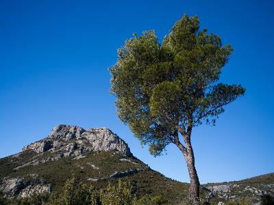
Garlaban is an enormous tower of blue rocks, planted on the edge of Plan de l'Aigle, this huge rocky plateau overlooking the green Huveaune valley. An immense semi-circular landscape rose up before me to the sky: black pinewoods, separated by valleys, would die like waves at the foot of three rocky peaks" Marcel Pagnol, in La Gloire de mon père.
You can do this itinerary from Roquevaire. This circuit is not recommended for children and is for experienced cyclists because of the steepness...Garlaban is an enormous tower of blue rocks, planted on the edge of Plan de l'Aigle, this huge rocky plateau overlooking the green Huveaune valley. An immense semi-circular landscape rose up before me to the sky: black pinewoods, separated by valleys, would die like waves at the foot of three rocky peaks" Marcel Pagnol, in La Gloire de mon père.
You can do this itinerary from Roquevaire. This circuit is not recommended for children and is for experienced cyclists because of the steepness of the slopes.
From the Maison du Tourisme du Pays d'Aubagne et de l'Etoile, turn left towards
Roquevaire, then right just before the market square. When you reach a traffic circle, turn left and after crossing the Planque bridge you will come to a new roundabout that you will take on your right towards Beaudinard.
Cross the bridge over the railroad and turn right onto the
RD 43a, then take the second road on your left in the direction of
Aubes (RD 43 b).
After one kilometer through the fields you will cross a crossroads, then join the RD 43 where you will turn
to the right.
After having passed the church of Beaudinard you will turn left on the RD 43f.
After having crossed the traffic circle and the railroad, turn right and then left in the direction of
Lascours (RD 44 e). This road which winds at the foot of the Garlaban will allow you to reach the small village of Lascours which is one of the starting points for hiking through this mountainous massif which local writers have made a legend of. Be careful because the ascents and descents that you will tackle have important declivities.
At the end of a long descent, turn left just before the narrow bridge over the old railroad.
After passing the Roquevaire college, turn right twice to reach the RD 45 which you will also take on your right in the direction of Lascours and then Pont de l'Etoile where you will find "la maison de celle qui peint".
After this house, turn right on the RD 96 in the direction of Marseille then after 200 meters turn right again and take the communal road which passes under a bridge. After two hundred meters, turn left.
Drive along the old railroad for about one and a half kilometers, then turn right. Once you reach a small traffic circle, turn right and then left to take the small path that rises through a pine forest.
At the top of the hill, cross the crossroads to go back down to Aubagne. Continue straight ahead on the Chemin de la Louve until the roundabout with the RD 44. Turn left, and after passing under the freeway you will go uphill followed by a steep descent to a crossroads where you will turn left again. At the traffic circle, turn right onto Avenue Roger Salengro, which will take you back to the city center.
- Departure
- Aubagne
-
-
Difference in height
- 267.333 m
-
-
-
Plain text period
- All year round.
-
-
-
Documentation
- GPX / KML files allow you to export the trail of your hike to your GPS (or other navigation tool)
-
- See all reviews
- 267 meters of difference in height
-
- Maximum altitude : 250 m
- Minimum altitude : 107 m
- Total positive elevation : 267 m
- Total negative elevation : -267 m
- Max positive elevation : 98 m
- Min positive elevation : -88 m
